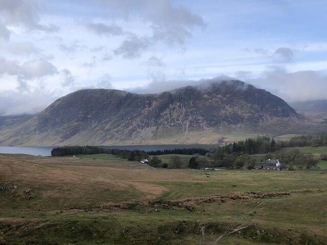
Mellbreak [Mellbreak South Top]

Mellbreak [Mellbreak South Top]

Mellbreak [Mellbreak South Top] Group Walks | Join a Walk

511m Elevation
259m Prominence
England Country

Join group walks, find walking companions and friends, or organise your own!

Classifications

Marilyn Dodd Dewey Wainwright Birkett Sy Fellranger

Looking for walking companions?

Don't walk alone! Find friendly walkers to explore Mellbreak [Mellbreak South Top] together. Join scheduled group walks or start your own.

Elevation

511m

1,677 ft

Prominence

259m

Coordinates

54.5556, -3.3183

NY148186

OS Map

89

Explorer: OL4S

At the Summit

The summit features a rocky outcrop that is perfect for a photo op, along with a small cairn to mark the high point. Be on the lookout for the local sheep, who might give you a judgmental stare for daring to walk on their turf!

Terrain & Geology

Rocky and grassy with some steeper inclines towards the summit. A few paths might be boggy after heavy rains so sturdy footwear is a must.

Mellbreak is primarily composed of volcanic rock known as andesite, which forms due to the cooling of lava beneath the Earth's surface. This characteristic gives the mountain a unique structure and colourful appearance, especially when the sunlight strikes it at the right angle.

Views & Scenery

From the summit, you can soak in breathtaking views of Crummock Water, the surrounding fells, and even distant peaks like Skiddaw on a clear day. The vistas truly reward your efforts with stunning natural beauty.

History & Heritage

Name Origin

The name 'Mellbreak' is derived from an old Cumbric term meaning 'bare hill', which is fitting considering the rocky outcrops that define its summit.

Historical Significance

Mellbreak holds local significance and has been a popular hiking destination for generations, often featured in literature and paintings depicting the stunning Lake District landscape.

Popular Routes

Mellbreak Circuit from Buttermere

Moderate

A popular circular route that begins in the picturesque village of Buttermere, taking you up the south face of Mellbreak and circling around the summit for panoramic views.

8.5 km 4 hours

Getting There & Facilities

Parking

There is parking available at the National Trust car park in Buttermere village, but it can fill up quickly during peak season. Arrive early to avoid parking woes.

Public Transport

Buses run from Keswick to Buttermere, making it accessible for those using public transport. Check local schedules for service times.

Nearby Facilities

While there are no facilities on the mountain itself, Buttermere village offers several cafes and a pub for post-hike refreshments, and public toilets are available nearby.

Safety Information

Known Hazards

  • Potential slipping on wet rocks, especially after rain. Always pay attention to local weather forecasts before venturing out.

General Safety Tips

  • Check weather conditions before setting out
  • Carry appropriate clothing and equipment
  • Let someone know your planned route
  • Take a map, compass, and GPS device
  • Carry emergency supplies: food, water, first aid kit, torch

Find Walking Companions

Join friendly walkers exploring Mellbreak [Mellbreak South Top] and surrounding area

Can't find a walk? Organise your own!

Create a walk and let others join you. It's free and easy!

Hills

Some common questions about the hills answered

Are there group walks up Mellbreak [Mellbreak South Top]?

Many walkers use Walkmates to join or organise walks with others. You can check for group walks around Mellbreak [Mellbreak South Top] through the maps

Are there other walkers around Mellbreak [Mellbreak South Top]?

Activity varies by location and time, but Walkmates lets you see whether others have shared walks or shown interest in this area. Find other people through the walking friends search walking friends for Mellbreak [Mellbreak South Top] search or of course create your own walk for Mellbreak [Mellbreak South Top]

Can I organise a walk to Mellbreak [Mellbreak South Top]?

Yes. If there aren’t any walks listed already, you can create a walk and make it available for others to join.

If you're signed up to Walkmates, you can create a walk to Mellbreak [Mellbreak South Top].

How do I find a walk up this hill?

There are often multiple ways to walk this hill, depending on experience and route preference. Walkmates helps you explore walks and routes that others have shared.

Can I suggest a new route up Mellbreak [Mellbreak South Top]?

Yes. You can suggest or create routes to share with others. Walkmates focuses on the social side of walking, so routes are used to help people organise walks and explore areas together, rather than as detailed navigation tools or route libraries.

Other uses really appreciate knowledgeable walkers sharing their routes. Share your favourite route to Mellbreak [Mellbreak South Top] here

The is an error or something incorrect about this hill. How do I let you know?

We always strive to keep the information on Walkmates as accurate as possible. If you find an error, please let us know through the contact form and we'll aim to correct it as quickly as possible